top of page
Home: Welcome
Summer landscape

DISCOVER THESNOWDREAMER'S
WEATHER KALEIDOSCOPE

Your Go-To Weather Man

Home: Blog2
Search

Monday has began more characteristic of a hot midsummer day particularly across SE England. Heathrow Airport hitting 28.6C making it the hottest day of the year in UK.


However, elsewhere there has been a weakening cold front moving slowly southeastwards which has brought much cooler and cloudier conditions. This cold front will clear through SE tonight so the night will be less warm and humid. Tuesday is expected to be less hot, with highs at best of 25C with high pressure fully in control it will remain dry with plentiful sunny spells across many areas. Although, an approaching frontal system from west will bring cloud, wind and rain to N. Ireland and western and northern parts of Scotland in afternoon.


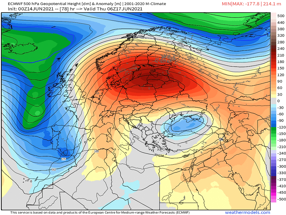
On Wednesday things become interesting a band of rain stalls across parts of Scotland and NW England during morning and dissipates (not that). We see the upper trough in Atlantic essentially an area of low pressure positioned to our northwest being forced and elongated south near Iberian peninsula, by the dome of high pressure in Europe. This helps pull in winds from a southerly direction introducing increasingly hot and humid air.


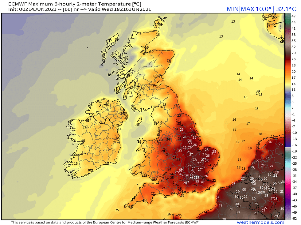
With abundant sunshine across eastern, central, and southern England temperatures will respond with 30C quite likely to be seen in London area.


But later in the day we see increasing instability generated by hot plume and into overnight Thursday we see a thundery low develop in northern France, this will drift north and is likely to bring an area of heavy rain and thunderstorms moving northeast across most of England and perhaps east of Wales most likely into early hours of Thursday.


These storms could contain prolific lightning, biblical rainfall, large hail and strong convective gusts I expect London, SE and East Anglia to have greatest risk of thundery action further west I expect less of a thundery nature more noted for their rainfall.


The humid and warm feel will continue through Thursday across eastern England with potential further thundery rain and elsewhere much fresher with decent sunny spells there could also be some showers most missing them.


On Friday further thundery rain is looking to advance northeast out of France once more largely across SE and East Anglia most areas staying dry and sunny, temperatures returning closer to average for the time of year.


Set to turn more unsettled next weekend, again we see low pressure moving north across France towards SE England the better day Saturday with possible early rain, Sunday a potentially larger area of rain which could impact much of the day.


Some welcome rain is to come following dry weather in recent weeks but perhaps some excessive amounts in places and increased risk of flash flooding owing to 'baked' dry soils. The second half of June is expected to be less settled and perhaps less warm but I anticipate a recovery, overall this June promises to be a solid summer month.

510 views0 comments

Meteorological summer is here, and attention is increasingly drawn to what the weather is doing; in a time of limited foreign travel, the weather the UK experiences this summer will be of particular interest. In this blog post I will explore how this season could be shaping up, some summer thoughts are also given to wider European region in introductory section.


This summer offers at the very least to be a reasonable summer, summers such as 2007 which happened to be a particularly poor summer, could be well flagged, in contrast to this summer we are transitioning to neutral ENSO, instead of La Nina (cold ENSO) which these conditions developed in autumn 2020 and have now faded in spring 2021.


La Nina is associated with cooler equatorial Pacific waters this tends to affect global jet streams they meander more and there more extremes, for NW Europe where UK is positioned, this often means we sit on cool/unsettled side of jet stream with Atlantic blocking.


This is what characterised 2007-2012 summers La Nina was highly influential on their unsavoury note. Ideally El Nino (warm ENSO) is best teleconnection for long, warm and settled periods across Europe given we have not long moved from La Nina, it is probable we are still seeing feedbacks between the cooler oceans and atmosphere. And, therefore it would be unwise to assume this summer will be a long hot summer, the interaction of much cooler Atlantic air may trigger intense downpours and violent thunderstorms.


This summer I'm expecting the most anomalous heat to be located across southern Europe with blistering heat surging from North Africa with temperatures exceeding 40C in Spain, Portugal, Italy and possibly the south of France. It is possible this extreme heat might nudge further north and affect more of Northern Europe including UK, however, while I'm expecting Europe to have a warm summer. The slight mobility in North Atlantic region might just be enough to ensure hottest conditions are kept further east. Furthermore, ensuring hot weather is not as prolonged unlikely to be as fortunate across European continent.


QBO (Quasi-Biennial Oscillation)


Is essentially the term we use to describe stratospheric winds around the equator. There are two phases either westerly or easterly in a 9-18 month cycle. What we tend to see is during strong positive/westerly, we see increased westerly flow across Atlantic.


This summer we are entering the summer neutral, May's QBO number comes out as +0.31 therefore one would expect June's update to show a negative value. It is possible by winter it could be in strong easterly phase so that is of interest to winter junkies but none of that now. The transition to easterly phase of QBO this summer is largely good news, on negative side of things the positive is that extensive Arctic blocking which featured significantly and resulted in UK's coldest April since 1989 and coldest May since 1996 has subsided. The danger with eQBO this can help solidify these blocking regimes at these high latitudes, so it is reassuring the Arctic weather patterns has changed. Nonetheless, this may change and reemerge this would be more likely during La Nina summers and as previously stated it has faded.


North Atlantic Sea Surface Temperatures (SSTs)


SSTs in proximity of UK have warmed albeit they are only a bit above average +0.4C around Ireland they are cooler than average, approximately by -0.5C. In May 2018 SSTs were very elevated within UK coastal waters and this helped influence the extent of high temperatures. We similarly had a cold blob in North Atlantic but this one is further east 'aimed' at British Isles. Where waters are warmer this increases risk of high pressure formation, and therefore these cooler waters just positioned to our west might be less good news. Particularly for those further west which could be at more risk of Atlantic incursions. Indeed, this is a reason why I'm anticipating this to be a thundery summer where we see significant clashes of air masses.


Waters in tropical Atlantic are cooler than normal this is main development zone for tropical cyclones which can develop into hurricanes, we don't see them but they do tend to recurve up eastern seaboard and hitch a ride on jet stream bringing disturbed weather to UK. I am personally not expecting an active hurricane season which runs from August to October, therefore. late summer could be less threatened by the remnants of these hurricanes.


ENSO


I will not go into much detail here as I have discussed 'simply' before most models in IRI/CPC plume predict a continuation of ENSO neutral conditions throughout the summer. This indicates there's unlikely to be a major shake up in summer pattern, while indeed we could at times see cooler and wetter conditions this will not persist for long. The neutralisation of La Nina during spring has been very helpful in that respect.


Lastly looking at seasonal models the ECMWF model SEA55 has changed quite considerably from May update, instead of ridging (high pressure) being focused in North Atlantic this is common in La Nina regimes. In June update we see main ridging extend across all of Europe which has potential to bring very warm and dry conditions across region. The mean flow is coming from Azores so an unpleasant summer of high humidity and rising temperatures could be on cards. There are hints of Atlantic troughing (low pressure) with Greenland having a cooler summer, this may mean NW airstreams could be rather cool. Overall best conditions expected further south and east as is the norm and the greater risk of wetter and cooler conditions further north and west.


Summer Forecast Breakdown


Temperatures


Quite bullish on a warm summer potentially very warm for SE England, for areas further north and west the summer might be closer to average with less desirable weather while areas further south and east might escape. I consider a cool summer very unlikely <10%.


70% chance of a warmer than average summer

20% chance of an average summer

10% chance of cooler than average summer


Precipitation


This is very challenging to ascertain firstly a washout summer is not expected (sorry Jack Reeves), overall a drier summer is more likely than a wet summer intense and short lasting downpours, however, have the ability of really changing things but it must be emphasised of the large local variation. From a statistical pov a wet summer might not necessarily feel like it has been wet. Driest conditions are expected in SE with wettest conditions in far NW where the weather will take a more changeable flow through much of summer. I'm anticipating the driest month could well be June and this might be shared across country.


June


The month has began well with high pressure in total control, there is no indication that a major change will occur in next 1-2 weeks, in fact the modelling is growing increasingly confident of hot conditions developing later this week, which I do anticipate first 30C will be met this weekend. The second half of June it is probable things will be shaken up, there could well be limited success from westerlies, and high pressure and warmth rules all the way through. I am expecting June to be driest month of summer, I also think temps will be well above average potentially by more than +2C which is quite significant. I do not think we will see hottest weather of summer but very warm weather will be regularly occurring.


July


Confidence truly plummets, I can see early in month featuring some less desirable weather and nowhere would escape from cooler and wetter conditions. Overall, expecting July to be less abnormally warm compared to June, nonetheless, I think we will see hottest weather of summer and temperatures may exceed 35C. Continental Europe could be subject to very fierce and persistent heat and this might bring great suffering to vulnerable groups. I anticipate this summer month will be the most thundery with potential for severe storms.


August


We're sort of guessing at this point there has been a strange regularity to August's failing to impress in 21st century the 1990s were a particularly good decade (in more ways than one), we have not managed similar consistent highs since. Will this August offer something spectacular? Probably not, but, compared to last summer Nina conditions began developing in August this allowed the 2nd half of month to really deteriorated following on from intense heat earlier in month. Broadly expecting August to be a good summer month more traditional, rainfall closer to normal, June likely dry and July could vary extremely from dry to very wet.


So there we go that is my summer forecast for 2021, it offers to be an exciting season in my opinion to keep up with latest developments follow my tweets @TheSnowDreamer


1,262 views0 comments

Yesterday, witnessed a major Sudden Stratospheric Warming (SSW) it is an event in which westerly wind 60N at 10hPa roughly 30km high in atmosphere, above Arctic, reverses to an easterly wind indicated by negative value, the easterlies will continue to strengthen.


Not all SSW events give the same outcomes, but far majority reshuffle weather patterns across Northern Hemisphere, sometimes the easterlies do not trickle to lower atmosphere and there is no impact as was evident in January 2019.


Some feature displacements and others splits, sometimes both, this Met Office video offers great visualisation and insight.


This reversal to easterly wind in upper atmosphere is an unnatural occurrence in winter time, particularly approaching mid winter, when stratospheric westerlies are at their strongest. This is why first half of winter tends to be more unsettled and mild, westerly driven, the strong stratospheric westerlies bleed into troposphere the part of the lower atmosphere, where weather happens, as we witnessed last winter. The extremely strong stratospheric westerlies were the direct result of February 2020 being the wettest February on record in UK.


Typical winter killer patterns with strong stratospheric westerlies/vortex, westerlies driven across North Atlantic and Europe is very mild with coldest air bottled up near Greenland.


There is greater climatology support for SSW as winter starts to fade out in Northern Hemisphere, why they're more common in February, as we had seen in 2018. The reversal of westerly wind is accompanied with a dramatic warming of up to 50C this warming fundamentally changes the structure and strength of stratospheric polar vortex, what we see is it goes from a concentric shape, compact keeping very cold air in Arctic to one that becomes more mouldable, in that parts can break away far south into mid latitudes.


Typical pressure patterns when stratospheric westerlies/vortex are weak often allows for high latitude blocking into Greenland ect, and the jet stream is much weaker and goes further south. We therefore often see the displacement of very cold Arctic much further south than usual. Approx 66% of SSW result in extended cold conditions in Northern Europe, so there's a greater likelihood in bringing cold, in fact the relationship is greatest in Europe. Hence why these events often excite, as we saw in February 2018 with the 'Beast from the East' spectacularly showed what a SSW can usher in.


But what is happening with this SSW? There are promising signs from ECM model that we're going to experience a relatively quick coupling towards day 10 - usually it takes 14-21 days to see an impact at earliest, worth noting we didn't see coupling happen in January 2019 SSW, the easterlies did not descend to lower atmosphere in which it can influence our weather patterns, so the early indicators with this SSW are I believe much more promising.

As you can see from the blues the easterly winds the day 9 chart from ECM shows the easterlies feeding all the way down indicative the impacts of this SSW will be seen.


In contrast to other winters we're not critically relying on a SSW the westerlies in lower atmosphere are unusually weak, and this has nothing to do with a SSW. As you will know the last 2 weeks have been on the colder side, a large swathe of country has seen snowfall but alas the lack of cold air, has meant significant cold has been absent.


And, we have seen more in the way of rain and sleet in SE England unfortunate given patterns but hold in there. A displacement is expected from this SSW they tend to not be as favourable as splits, but this one could position itself to be rather favourable to Europe. There is some hints in modelling we could see a split mid month in February 2018 we had one.


The modelling is suggesting a transfer of the polar vortex to Russia and a part to N/E Europe what this means there's going to be extensive deep cold relatively close to UK something of which so far this winter has been missing.


ECM 12z of yesterday very much displayed an air mass slamming SW into Europe evocative to the Beast From The East and that raised a few eyebrows.


I do think realistically this is a bit too rushed, nonetheless in the final third of January, there is a risk of exceptionally cold conditions to come from east the Met Office in their extended outlook have in fact mentioned these very cold conditions in Scandinavia could cross the North Sea. This transpiring would result in heavy, disruptive snowfalls across eastern half of England. I am not guaranteeing it, we are trusting on blocking close to UK to help direct it our way, but there is a heightened chance.


The position we find ourselves has the greatest interest since February 2018.


Even in event later January was to fail to deliver, given how powerful this SSW is looking it is likely the remainder of the winter through February, and even into early Spring will have a higher chance of cold and wintry conditions. So a lot to watch closely right now. Buckle in.


Dan

816 views0 comments
bottom of page