Well here we are, again, meteorological winter is here, and increasing numbers of you, and me, look for nirvana of winter weather to break tedium of monotonous nature of winter.
We move into this winter with very low expectation but is that unreasonable? Given the law of averages, and how shockingly poor it has been post March 2013. We head into this winter rather different on recent winters we have passed solar minimum, and have entered a new solar cycle, it is our first La Nina winter since 2017-18 which featured 'The Beast From The East', and the strength of La Nina is strongest since 2010-11. There are growing hints the stratospheric polar vortex (SPV) might be less of a bully this winter, in contrast to last winter which engulfed any opportunity to break out the rut.

Fading light. Canvey Island seafront late February 2018 during 'The Beast From The East' @olearydanny
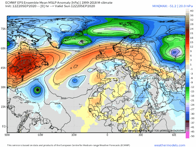
Many argue a mild November has poor implications for winter, but this is unclear, this November has experienced very mild weather. We have seen a strongly positive Arctic Oscillation (AO) a low pressure dominative environment in Arctic. While across Europe we have seen persistent higher pressure centred right at heart of region. Refer to below 500mb height anomaly. The positive AO has meant the cold from high latitudes hasn't had chance to bleed into mid latitudes - two of strongest positive November AO months were 1978 and 2013, these winters on opposite ends of the spectrum.

Interesting Central England Temperature (CET) for November 2020 came out as 8.5C identical to November 1978. The winter of discontent 1978-79, Britain suffered socio-political crisis exacerbated by the coldest winter for 16 years. In some ways the country is at a similar crossroads, and in the midst of a pandemic the like we've never seen. A cold winter is not typically welcomed by Brits but perhaps even more so this year.
So, what can we expect this winter? I will explore the seasonal models, sea surface temperatures and various other teleconnections like ENSO to construct this winter forecast, seasonal forecasting is very challenging, it is a rather new science but there are methods in the madness, (scroll to the end to skip the jargon).

Pinky sky following recent snowfall in December 2017 near Goring in South Oxfordshire @HelenAdams85
ENSO
The El Nino-Southern Oscillation (ENSO) is one of Earth's most influential ocean-atmospheric climate drivers ENSO describes variations in ocean temperatures in Equatorial Pacific.
During a cold ENSO event referred to as 'La Nina' which happens every 2 to 7 years, we see colder waters across east-central Equatorial Pacific.
The trade winds which blow east to west become even stronger no one quite understands why, in El Nino it is vice versa they're weaker and less oceanic upwelling causes a warming.

This winter will be a La Nina winter and of moderate strength it has likely peaked and expected to weaken as we move into spring. During La Nina winters we in Europe and USA see more colder winters than compared to warm counterpart, however, when strong this greatly increases the risk of a mild, very strong Atlantic zonal flow to the winter. December 2010 was a huge oddity in that sense but again highlights Mother Nature will sometimes do as she wishes. What we have also observed is East Based (EB) La Nina winters in which the core of cold water is in eastern Pacific east of 160 W is more favourable to colder winters in Europe, and during Central Based (CB) the core of cold waters are west of 160W this has a greater tendency to the traditional La Nina, with encouraging undisturbed zonal/unsettled flow.
This winter we have a more EB La Nina than CB La Nina although it is no classic, the strength of La Nina expected and core of cold the analogues tends to favour a colder winter overall but not by much over a warmer winter.

@longrangesnow analogue for this winter with an east based moderate La Nina reveals an atypical picture evidence of northern blocking in Kara Sea. Interestingly, current sea ice coverage in region is only 50% of 2010s average, there's an idea more open waters causes more latent heat flux to escape into atmosphere. And, subsequently more high pressure formation perhaps explaining why Arctic is warming much faster than elsewhere.
Notably this Kara Sea blocking also has association to preconditioning for Sudden Stratospheric Warmings (SSW) of which 2/3 result in cold conditions in Northern Europe, across Northern Hemisphere the mid latitudes tends to see more cold or very cold outbreaks.
Also analogue captures not the conventional west to east movement of Atlantic lows, the Azores high is nowhere to be seen a winter killer in Europe. This suggests a very wet winter for Iberian peninsula with the jet stream on a NW/SE axis, funnily we're seeing this now, with UK on colder more unsettled side of jet stream, I do not believe this suggests the winter will be very unsettled for us tending towards average rainfall, with wettest conditions in west the wetter weather perhaps going to Southern Europe which is anomalous. There's not a great indication for a particularly cold winter, frequent polar maritime remember 2014-15? Probably not if you're a southerner, it was an average winter only 0.2C warmer than 2017-18.
Overall this likely would result in a slightly colder and drier winter overall across British Isles and much of continental Europe.
Quite a bleak signal for SE Europe with ridge although inversion cold could be seen, there is also potential from this analogue of cold easterlies. Particularly in Eastern Europe, I get the impression at times this could creep our way, and bring very cold conditions, and with Atlantic trying to get in this spells potential for disruptive snowfalls particularly in eastern half of country. This winter is rather likely to offer much more wintry interest than preceding two.
Stratospheric polar vortex
Moving on the stratospheric polar vortex (SPV) a very vital element of consideration in our winter prospects essentially it is a huge area of very cold, low pressure which forms in autumn with return of polar night, it spins anticlockwise at North Pole in December-January it reaches peak strength. The stratospheric circulation is higher in atmopshere above the troposphere, the troposphere is where the weather happens, what we see with stronger stratosphere polar vortex (SPV) is like paint dripping down a wall the enhanced westerlies high in atmosphere propagate down into troposphere and we see a strong tropospheric polar vortex (TPV). This, therefore accelerates the speed of the jet stream a strong jet stream is likely to bring lots of low pressure, wet and windy weather at our latitude.
The stratospheric zonal wind at 60N at 10hPa (mid level of stratosphere) is currently significantly stronger than average GFS analysis reveals 44.4m/s (03/12/20) the average for date is 30m/s. Immediately this may seem alarming for this winter but there is more than meets the eye by through looking at Northern Annular Mode Index (NAM) which is very useful as it shows a cross-sectional profile of the atmosphere.
Positive NAM values essentially indicate to positive AO when you see these positive numbers from top to bottom, it means the troposphere is coupled with stratosphere, very hostile for cold weather patterns. And, very briefly this was evident at the end of November. However, looking forward an increasing disconnect looks to open up between strong stratospheric vortex which is intent on making our lives a misery and troposphere. Which is very good news indeed there are also signs of a considerable weakening in the upper levels of stratosphere, particularly from mid December onwards. In this instance we do not want to see a disconnect between higher and lower atmosphere, seeing negative values from top to bottom would be very good in identifying a weaker polar vortex, and one which can impact on weather patterns lower down in troposphere. The good news there is evidence of this going forward.


A sudden stratospheric warming (SSW) is what we often look for in winter it refers to a rapid warming in stratosphere of up to 50C in 10-15km above the Earth's surface which can have a fundamental change on our prevailing weather. Typically, the polar jet navigates from west to east very much around the periphery of polar vortex, however, this ordinary westerly/zonal flow can be disrupted by large disturbances which propagate upwards from lower down in atmosphere in troposphere. This usually involves anticyclonic wave breaking which happens around large areas of high pressure, we are seeing such wave breaking now, and it is tied to weakening of SPV but a more significant warming isn't expected presently in near future.
Sometimes these disturbances are sufficient to weaken and even reverse the westerly flow very high in stratosphere to easterly. These easterly winds eventually propagate down it can take several weeks which can greatly increase the chance of northern blocking and cold weather patterns, however, it is worth noting not all SSW events manage to propagate to troposphere. With SSW approximately 2 in 3 result in extended cold weather in Northern Europe which is significant given we are a small island nation a little less likely.
February 2018 was our last successful example and involved a split in polar vortex which Europe spectacularly benefitted from, splits tend to be much more 'rewarding' than displacements in Europe. Often significant area of bitterly cold air is dislodged. We see splits from wave 2 attacks which could involve a large anticyclone in Scandinavia and North Pacific, think of a balloon being pinched on both sides, it is more likely to burst.

The SSW in early February 2018 and split notice two main vortices completely separated
The far majority of SSW events in 21st century including 2009, 2013 and 2018 have worked greatly in our favour January 2019 one occasion it didn't work out. I believe given we appear to be going against climatology this December, I strongly think a SSW is more likely than not this winter. More importantly 50% of La Nina winters with wQBO which I will go onto soon have featured SSW. I'm 60-70% confident of a significant disruption, possibly as we pass into the New Year. In this instance I think the earliest we will feel its impact will be in second half of January and into February, it is also typical when vortex is seriously perturbed for the westerlies to be flushed down into troposphere in which is why, I anticipate January to potentially have some of most unsettled weather.
Solar
We are heading into this winter entering a new solar cycle, 25, the beginning of a 11 year solar characterised by both ends with low activity and the maximum midway in cycle, solar maximum which is expected in 2025. We are in ascending phase from solar minimum in contrast to cycle 24 the wake up has been more abrupt than perhaps expected. Nonetheless, there's evidence in previous years of uptick following solar minimum this having strongest relationship on colder Northern Europe winters not in the thick of solar minimum. Indeed as we had seen in 2008, and colder winters which followed in those years after 2009-2013. Current solar flux interestingly is very similar to late 2010. Overall, solar activity is expected to be low or moderate this winter and following solar minimum this winter will be well tested.

03/12/20 - the emergence of sun spots in the Southern Hemisphere of Sun's surface
Arctic Sea Ice
Sea ice extent is currently second lowest 1979-present after 2016 this may indicate northerly flows may not be as cold, this is perhaps why seasonal models are showing some of most anomalous warmth in Europe across Scandinavia this winter. However, sea surface temperatures (SST) have lowered in Norwegian Sea from a very elevated state. On paper this bodes badly but there is early research which is attributing to a warmer Arctic with increased northern blocking, and cold weather patterns in mid latitudes.

Sea surface temperatures
SSTs in November took a large downwards plunge in North Atlantic cooler waters increase propensity for low pressure, and therefore the "warming" seen as we have moved into December is a positive development for -NAO and blocking patterns in this region increasing risk of cold northerly winds in Europe. During La Nina winters we tend to see increased Atlantic blocking, indeed for much of Autumn we did see this, October was cooler than average across Western Europe and France had their first below average month since May 2019. November, however, has been atypical for La Nina, there is evidence now of disconnect with La Nina state ending which particularly increases risk of colder weather earlier in winter.
Many winters in last decade which mild conditions have dominated have witnessed large cold anomalies in North Atlantic, to me this suggests the Atlantic flow will be weaker than normal this winter, and therefore such an unsettled winter like 2019-20 winter is extremely unlikely.

QBO
Sorry if you're getting increasingly restless at this stage but the end is nearly in sight. The QBO (Quasi-Biennial Oscillation) refers to the variation in winds we see in equatorial regions high in stratosphere. Roughly every 14 months the winds change direction from westerly to easterly or vice versa. It sort of has a butterfly effect around globe when the QBO is easterly there is a greater chance of a weak jet stream, SSW and therefore colder winters, when in westerly phase the total opposite.

This winter the QBO is behaving oddly it is sort of in a neutral position the lower atmosphere has weak easterlies which is most important, this is positive in that there are not westerlies to enhance the zonal westerly flow. Which may be a contributive factor why this December is expected to have little impetus in Atlantic and therefore a greater chance of colder conditions in Europe. We are also beginning to see descent of easterlies in upper atmosphere between 10hPa and 20hPa this is the beginning of an easterly cycle, which we are quite confident winter 2021-22 will feature eQBO, it is possible this could descend by spring 2021 which would increase the chance of an extended winter not welcomed by me. It is difficult to make sense of QBO and its future this winter, but overall I'm not expecting QBO to be hostile the westerlies in mid atmosphere are trying to descend, but thus far are being hold back.
Seasonal models

The GloSea5 model the best long range model in business, I believe in last 10 years it has got 8 out of 10 right in our part of the world, it forecast winters like 2009 and 2010. Unfortunately, the December update is still not out, in this time there's been increasing hints of disruption to SPV which could break normal Nina coupled state especially further into winter. There is clear evidence of a La Nina signature the North Pacific ridge, western Canada and Alaska seeing a very cold and snowy winter, very mild in the eastern half of USA. Europe seeing a blowtorch winter +NAO/+AO dominated, very anticyclonic.

ECMWF seasonal model MSLP probability shows evidence the Azores high will be retracted to our southwest possible ridging in North Atlantic interesting to note there's no strong signal either way for anomalous low or high pressure in Greenland. In recent years many seasonal models have taken to Greenland with significant low geopotential heights, +NAO identifier, very hostile profile for cold weather patterns in Europe. This doesn't scream a cold winter but nor a mild one, the polar jet is displaced bit further south, I can see potential for northern areas of UK seeing lots of snow potential from this, infrequently in south. Winter rainfall likely to be near normal the Atlantic isn't particularly energised.

JMA model I do not have experience with this model but it goes further than ECMWF the macro scale features are very alike. There's more evidence of ridging in North Atlantic at a higher latitude into Greenland. This would have the potential to give a quite cold winter with plenty of cold northerly or northwesterly winds winter rainfall likely below average.
In conclusion none of the seasonal models I've come across are really forecasting a really cold winter the ECMWF and JMA are broadly similar with potential to bring quite frequent colder than average conditions from a northerly quadrant.
JMA model has greatest potential to bring something more significant and more countrywide, rather than limited to northern locations. It should be noted caution with interpreting a 3 month smoothed average, it is possible one winter month might feature more blocking for example. The GloSea5 very little wiggle room - very poor. Generally a positive change on recent winters in that Greenland doesn't look to harbour the PV.

In village of Iwade, Kent an 'Arctic landscape' February 2018 @iOS_weathervue
December
The first month of winter offers to be a seasonal month, I see it to be a remarkable month in the absence of exceptionally mild temperatures we have been so accustomed to. There is a good chance this will be coldest December since 2010, but this rather says much about how poorly we have done since 2010. The North Atlantic Oscillation (NAO) is looking to have a negative tendency, and therefore the pressure gradient between Azores High and Icelandic Low is reduced hence colder weather patterns are more likely to feature in Europe and a barrage of Atlantic lows are unlikely. Heading towards mid month I think it could it turn milder with Atlantic air breaking in, there could be snow in this process, however, there's a chance we could remain colder and go even colder. Towards Christmas week we may see reemergence of Scandinavia blocking given developments in MJO, and colder weather possibly from east, perhaps more dry weather, the chance of a white Christmas this year is higher than usual. I think a significant cold spell is unlikely to feature this month, nonetheless many could see their first snowfall, even disruptive snowfall, more likely in north and east. Rainfall probably below average, more likely wetter in west and drier in the east.
January
This month is particularly tricky in that I'm somewhat making an assumption but based on developing trends that a major disruption to stratospheric polar vortex is going to happen, I do not expect for this winter that we will have to have a SSW for there to be a chance of a good cold spell, as we had seen in December 2019 it become very rampant and only got progressively stronger. Vortex become one of strongest on record in February 2020 not coincidental it was the wettest February on record in UK.
With December 2020, it is going in a differing direction as December progresses a weaker vortex is signalled, and therefore this is very different to last winter. I consider it unlikely that much of this month will be cold, it may even turn out milder than average, but not particularly so. Later in the month I can foresee the potential for coldest spell of winter, and I believe this would come from the east or northeast. Beforehand it could be very unsettled as the westerlies are flushed down from stratosphere into troposphere to make way for the easterlies which will descend. Potentially January 2021 will be the wettest month of the winter.
February
I feel this month is more likely to begin on a cold or very cold side following on from the fallout of SSW and perhaps ending on the cold side as well, it is infrequent we just have one long continuous cold spell in Febuary-March 2018, we had a baby beast but as it was so late in season it was a damp squib. My inclination is that February will be driest month of the winter.

A snow coated bicycle in East Sussex early February 2012 @pete7777
Winter 2020/21 summary
* Near average winter leaning on the colder side
* A drier feel but not particularly dry or wet
* 60-70% chance of a sudden stratospheric warming in January
* Not exclusively front loaded often associated with a typical La Nina winter
* The greatest potential of significant winter weather coming January into February
Overall, I fancy this to be a near average winter which on recent winters will feel cold. I'm leaning more on the colder side than the warmer side of average, there is potential for some particularly cold weather coming from east, and I consider this most likely to happen in second half of winter from mid January onwards. Precipitation wise I cannot see it being nearly as unsettled as last winter particularly in the case of February, the signals aren't strong either way wet or dry, so I expect average rainfall to be more likely.
There's a small chance <20% every winter month could be colder than average, we could see an appreciably colder than average winter the coldest as far back as 2009-10. Perhaps more likely to be closer to winter 2012-13 which was 0.4C below average in UK a good winter.
To wrap it up this winter promises to be no different to any other, the inevitable feelings of euphoria following a frigid GFS model run only for it to be coldly snatched away. However, this time I do not expect an endless chase, the pointers are different this winter and present is unordinary which inspires hope. I hope this forecast provided to be of interest and of educational benefit I enjoyed typing it, I'll catch you later!
Dan