Following weeks of unseasonable sunny and balmy weather you would by now have caught on a major change in our weather, reflecting the descent into crazy season. It was only last Tuesday, we had a very warm southerly flow, which enabled temperatures to reach as high as 31.3C in Kent the first 30C+ in September since 2016.
A major change occurred on Wednesday and it is expected these cooler and more unsettled conditions will continue for remainder of month and continue into early October.
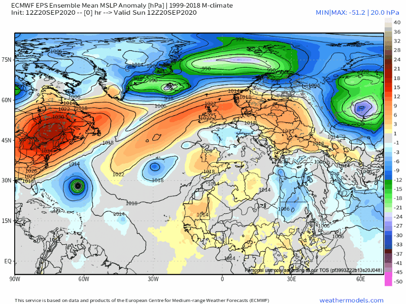
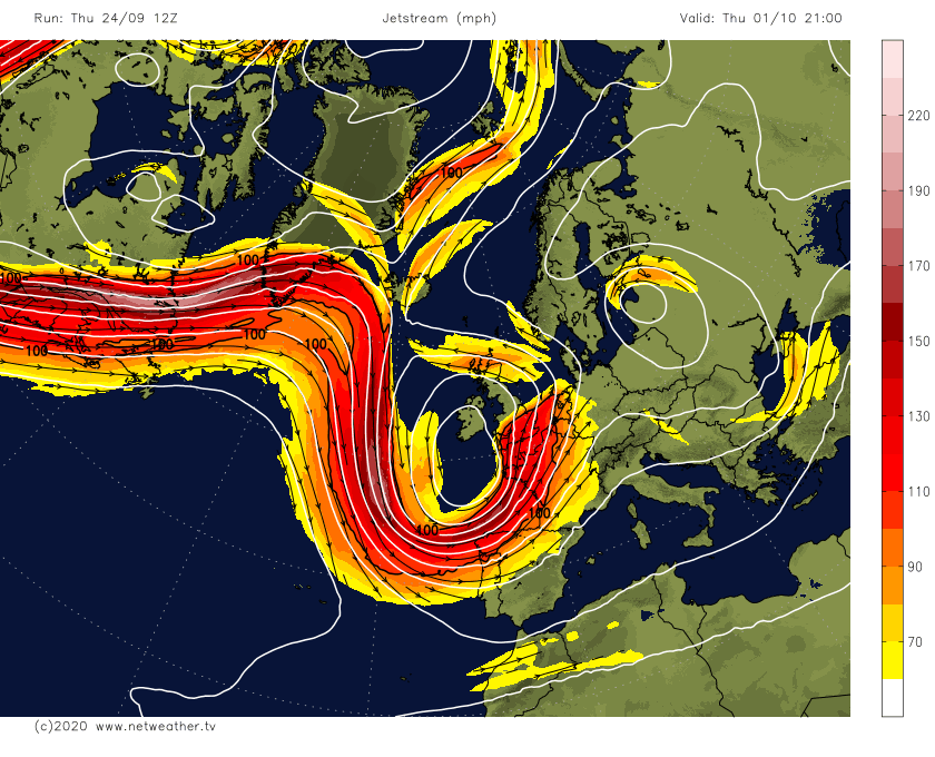
The cause for this change and big fall in pressure, stems from what was Hurricane Teddy which has trundled through easternmost Canada and to Greenland its impact on the jet stream causing a wavy configuration. As such amplifying the ridge (dry and settled) poleward in mid Atlantic and sending a trough (wetter & cooler weather) downstream into NW Europe.
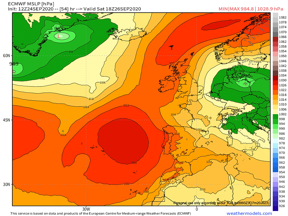
The weekend will be on cool side temperatures generally 10-14C warmest in south, however, following some recent rain, we will see high pressure, nudging in from west and hence the weekend will be largely dry with sunshine. On Saturday there's likely to be showers moving in across easternmost counties off North Sea... particularly Kent & Norfolk. Sunday will see it turn dry across all areas, with lighter winds making it feel less cool especially in east.
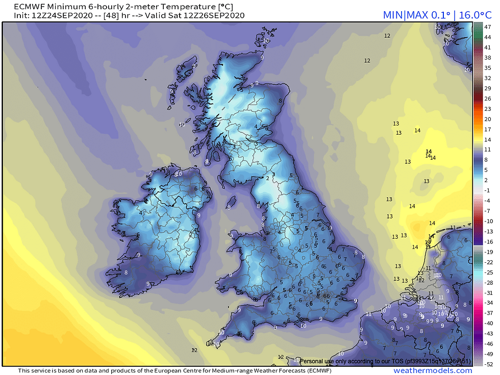
Winds will fall light especially further north and west meaning frost is likely to develop Saturday and Sunday AM. In contrast less light winds and cloud further east may keep frost at bay.
Saturday morning minimums
Next week: on Monday we will see a frontal band moving eastward with cloud and rain across all areas, however, it will be a decaying feature and therefore may give no rain for South East and East Anglia. Feeling milder with southwesterly winds instead of cool northerly winds. Tuesday sees a brief area of high pressure nose in south, meaning mostly dry and bright conditions particularly in south, temperatures near normal for time of year. After a break from more unsettled conditions midweek onwards we see the jet stream strengthen and this helps introduce a series of low pressure systems.
Wednesday likely remaining dry for many however low pressure is expected to dive in from northwest late in the day, there is the expectation this area of low pressure will linger around not necessarily meaning continuous rain, but very squally, showery conditions.
Model output deepens this low pressure through Thursday and Friday bringing very windy conditions and gales for exposed locations. Feeling cooler once more on north side of jet stream with cooler Polar Maritime airmass firmly established.
What of winter? As you know we're still in September with still 9 weeks till December 1st, so much can chop and change, nonetheless, the atmosphere can give some longstanding clues in autumn with possibilities for early winter.

The autumn so far has certainly been interesting, and is progressing quite unusually. So far one overwhelming characteristic has been jet streams behaviour, it has been more meridional (wavy) than normal. The mid month European heatwave was caused by jet stream looping aggressively north of British Isles and up to Scandinavia, allowing very warm continental air to seep north from Spain and North Africa. Being south of jet stream means 'warm' and settled conditions. Now, for foreseeable future we look to sit on northern side of jet stream the cooler and wetter side. These wild fluctuations in jet stream, potentially has links to solar minimum conditions. Indeed there has been a lot of similarity with 2008 that year it was also declared. During that October, London had experienced earliest snow since 1934, I am not suggesting we are going to see the same, but there appears to be a greater risk of a more unseasonable, potent cold snaps in October and November and potentially into early winter.
That winter began a cluster of much colder winters between 2008-2013. The autumn of 2008 similarly featured a wavy jet stream, and Atlantic blocking which looks to dominate persistently in near term, this continued through winter and indeed this winter was coldest winter in UK since 2000-2001. The winter which followed this was 2009-10 which was coldest winter since 1978-79, and not long after in December 2010 we witnessed coldest December since 1890, there is literature which suggests the effects of solar minimum are most pronounced 2 years after. It is worth noting these winters came after a long barren spell through much of late 1990s and 2000s we are no stranger to lengthy snowless periods.
Ural blocking over NW Russia looks to feature extensively in outlook, there are studies which attributes the diminishing sea ice (this year we experienced the second lowest sea ice minimum extent after 2012 since 1979), to greater likelihood of blocking in these higher latitudes. The ice free areas release more heat to the atmosphere, and can affect the atmospheric circulation patterns. An interesting but very plausible theory, it would mean in this event the Arctic would experience more rapid warming and indeed it already is experiencing but the mid latitudes like Europe would be more prone to 'The Beast From The East', however, remaining uncommon but perhaps with increased frequency of extreme cold spells.
The Ural blocking is also linked to disrupting the Polar Vortex particularly pertinent the link from November and increasing the chance of -NAO in December and January, hence a greater chance of colder weather patterns for NW Europe and more settled conditions.


It is linked as a robust driver to early winter stratospheric warming for NW Europe the polar vortex is a winter troll, a strong vortex encourages strong thermal gradients, therefore the intense cold remains bottled in Arctic & mid latitudes do not see this cold air. And, therefore we see see a strong baroclinic zone, where low pressure can rapidly form. When it is disrupted, the very cold air is much more likely to bleed out and increase cold risks markedly.
Guidance resolutely is going with a weaker polar vortex through much of October even adjusted CFS which is known for its weaker bias, is going for a weaker polar vortex into early winter, and therefore we may have the greatest shout of cold and snow early in the winter.

In conclusion I must say I'm feeling quite positive overall for early winter prospects, it is even possible November could deliver something wintry, which we haven't seen in 10 years. I see something a little different about this upcoming season, you may feel you hear that every winter, but we have decidedly different variables to work with this winter. I've chosen not to go in great length, there'd be no point now. In contrast to last two winters, snowless and terrible, we are set to have La Nina conditions again this is correlated to a front loaded winter. Although of course it's worth noting winter 2017-18 was also La Nina, the most intense cold of the winter did come in February and March that was brought by a Sudden Stratospheric Warming (SSW). However, the December was not without interest with multiple snow events but SE England largely missed out there. It illustrates things are never black and white with weather, which makes it very challenging, but there's no harm giving it a good go.
コメント