
Winter Forecast Headlines:
Overall, over the course of the meteorological winter encompassing the months of December, January and February. Temperatures are favoured to be colder than normal to 1991-2020 winter climatology and perhaps even significantly so. I am the most bullish of a colder winter since I've been producing these winter forecasts the reasoning will be laid out in this report.
Generally, near normal winter rainfall, I believe the most anomalously wet weather will tend to be seen in southern UK. The jet stream being dispaced further south with subtropical high pressure system known as Azores High which brings warm winter weather to Europe will be more withdrawn. I believe this will be a source of continuity through this upcoming winter.
I'd like to begin this forecast with a caveat; seasonal forecasting is very challenging this forecast is somewhat experimental but scientific. It combines a number of key drivers to produce this winter forecast. I will outline them one by one, it is these "background signals" and their interrelationship that drive numerical weather prediction (NWP).
ENSO (El Nino Southern Oscillation)
There are 3 states to ENSO, in recent winters we have seen La Nina conditions, associated with colder than normal sea surface temperatures (SST) in the central and eastern tropical Pacific; neutral conditions suggesting close to average SSTs or El Nino which is the opposite of La Nina, where much warmer waters in equatorial Pacific dominate.
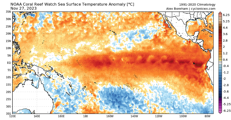
Tropical Pacific Sea Surface Temperature Anomaly (°C) Nov 27, 2023
As can be clearly identified by the above SST chart we are firmly in warm ENSO conditions warm waters span the entire basin, but the warmest waters are in the east closest to South America. This is known as an Eastern Pacific (EP) El Nino it's important to know there are many "flavours" of ENSO there are different types of La Nina and El Nino with different influences to global weather patterns. This El Nino event is expected to peak from now to January beginning to weaken by late winter and spring, nearly all models are showing a moderate to strong El Nino and they transition to ENSO-neutral by summer 2024.
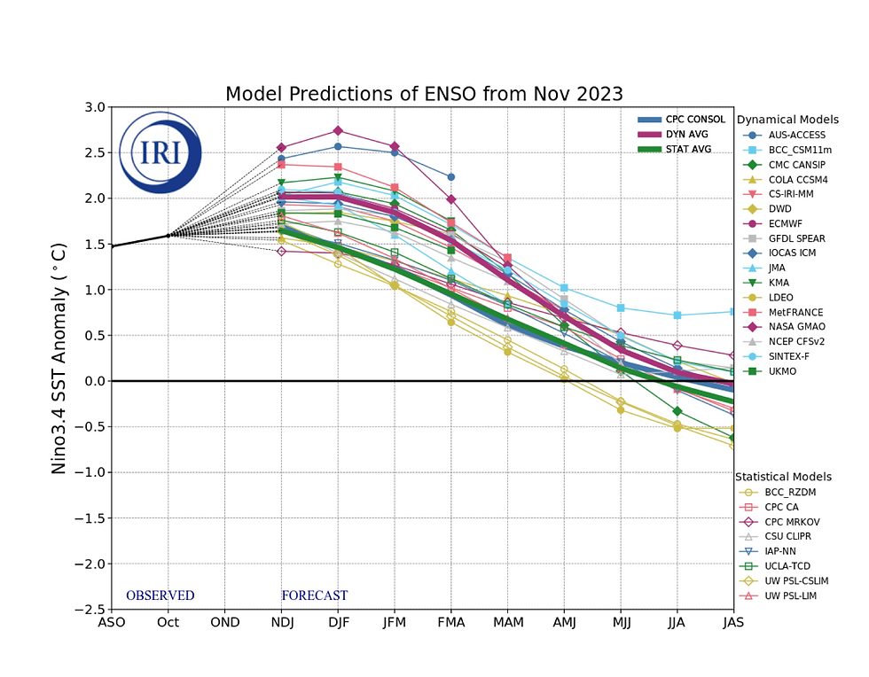
Model Predictions of ENSO from Nov 2023
"El Nino winters have a tendency to have a mild and westerly start to winter (Nov-Dec) and a colder, drier end to winter (Jan-March) across most of Northern Europe," Professor Adam Scaife (2023)
It's interesting to me the upcoming disconnect of colder weather patterns in Europe with normal expectations from El Nino winter. I believe the MEI index reinforces the atmosphere is not yet truly connected with strongly developing oceanic El Nino. After a very unusually persistent La Nina event 2020-2023, perhaps it is unsurprising that the atmosphere could be lagging behind. Hence, our weather patterns in early winter are not yet being greatly influenced by El Nino, which would oppose colder weather patterns earlier in winter.

Multivariate El Nino/Southern Oscillation (ENSO) index against strongest El Nino years
I think among many other factors yet to be discussed this points to a winter which has the potential to be well-rounded in terms of cold risk with similarity to winter 2009-10. It is likely El Nino will connect more strongly to the atmosphere later in winter, but by then El Nino (albeit not super strength), is known to increase the probability of late winter wintry patterns. Whilst the high global temperatures are clearly unsupportive for a cold winter and there is some concern, not everywhere can be mild simultaneously. I theorise Northern Europe could well be the cold anomaly this winter.
North Atlantic Sea Surface Temperatures
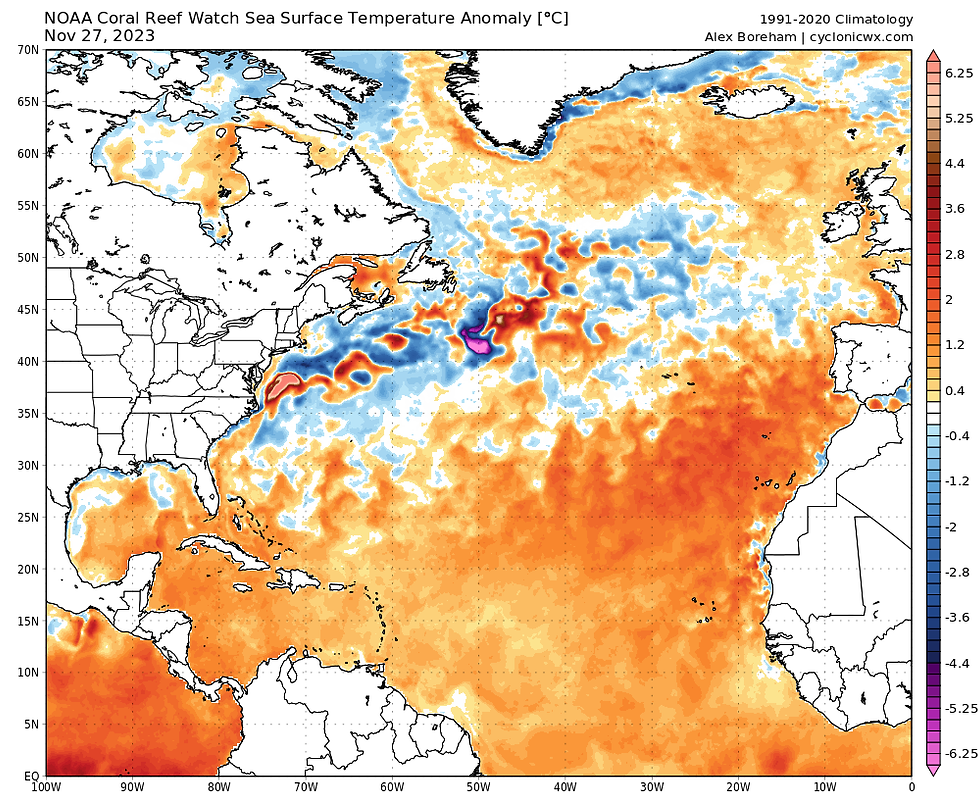
Atlantic Sea Surface Temperature Anomaly (°C) Nov 27, 2023
Owing to our exposed geographic area in NW Europe to edge of the Atlantic Ocean, sea surface temperatures (SSTs), are really quite an important area of focus in producing a seasonal forecast. As can be seen warmer than average SSTs dominate Atlantic, but there is a band of cooler waters off Labrador and East Coast which cross mid North Atlantic and up to Bay of Biscay. Often we see serious Arctic cold spill out of Canada and this collision with much warmer waters greatly strengthens the Atlantic jet stream bringing wet and windy weather to NW Europe. The cold SST anomalies off Labrador therefore are a good thing to see if looking for a weaker Atlantic jet stream, the fact the band of cooler waters is displaced further south is also indicative of the storm track (jet stream) being further south.
The warmer waters at higher latitudes of Greenland & Iceland are also interesting, this is indicative of a lack of stormy wind in this region which upwells much colder waters from depths. The North Atlantic Oscillation (NAO) is a highly influential atmospheric system in North Atlantic that can greatly influence wintertime weather in Europe. The positive phase of NAO corresponds with below-average sea level pressure (SLP) across high latitudes of North Atlantic often the strength of Icelandic Low is used, and above normal SLP over central North Atlantic. Positive NAO results often in a mild, wet Europe. The behaviour of NAO can be influenced by multiple factors but SSTs are also important. I believe the SSTs this upcoming winter season are more supportive of negative NAO atmospheric circulation in North Atlantic. This is associated with above-average sea level pressure across high latitudes of North Atlantic. Therefore, in my opinion, colder weather patterns this winter have a greater chance of occurring than in many recent years where +NAO has dominated.
Northern Hemisphere snow cover
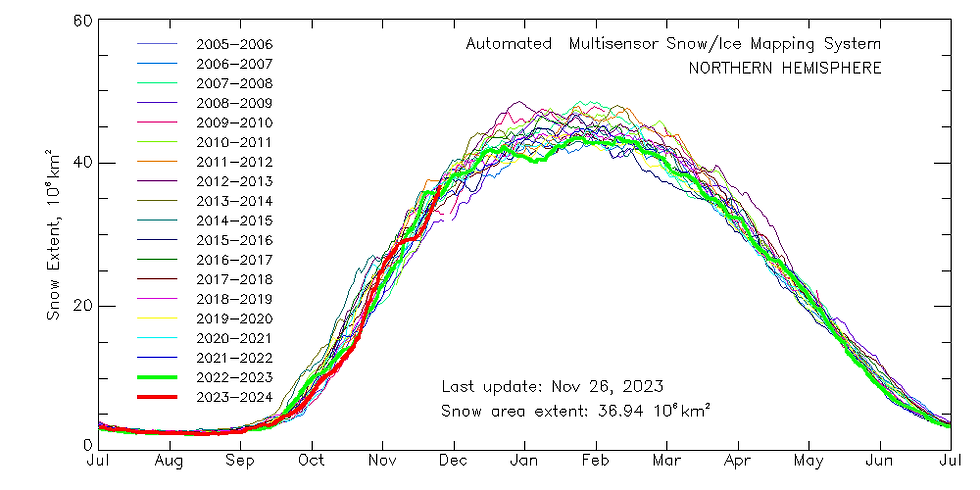
Snow area extent in Northern Hemisphere 2005-2006 to present 2023 indicated by red line
After a rather sluggish growth to snow extent in the Northern Hemisphere during November with very mild patterns dominating in North America and Eurasia, we have seen a strong rally in the last week with colder temperatures. This has taken 2023/24 as of Nov 26th to climb above this point in 2022/23 which was slightly above the latest 18-year average. Overall, this is a good indicator to colder weather while I will say with this factor it is more tenuous one I believe it is important. When snow covers the ground the incoming radiation is reflected back to space. The albedo of fresh snow cover can be as high as 80-90%, therefore, snow cover makes it colder than it would be otherwise, the fact large swathes of Northern Hemisphere have a healthy snowpack could prove beneficial later on. An easterly flowing through a snow rich Russia/Scandinavia towards UK will be colder, and therefore, more fruitful in reducing cold modification from warmer waters surrounding us.
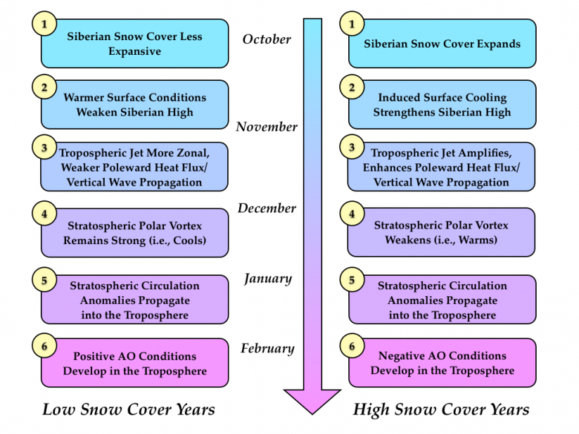
Some researchers use the Siberian snow cover extent in the autumn for more accurate winter predictions. Cohen et al (2007) discuss that increasing snow cover particularly in Northern Asia, leads to stronger diabatic cooling and a strengthened Siberian high. This further leads to an increase in upward propagation of planetary waves resulting in a weakened polar vortex and westerlies, with a strengthened meridional flow. Associated with a wavy jet stream and high lat blocking with an increase of cold Arctic outbreaks in mid-latitudes like in Europe. Whilst a low snow year would result in a strong polar vortex with strong, mild westerly flow.
Stratospheric polar vortex (SPV)
The stratosphere is in the layer of the atmosphere situated between 10km and 50km above the Earth's surface, being above the troposphere the first layer of atmosphere responsible for the weather we receive on the surface. it is important to understand how the stratosphere may affect the winter tropospheric pattern.

How does it form?
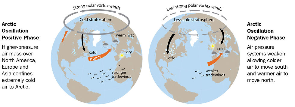
Every autumn the stratosphere cools drastically as less UV radiation is absorbed by ozone content in the stratosphere. The increasing differential between the Arctic and warm latitudes further south combine to form and strengthen the wintertime stratospheric polar vortex. Rather easy to understand the colder the stratospheric vortex the stronger the polar vortex becomes with stronger upper westerlies associated with trapping the cold in North Pole. The stratospheric vortex has a strong link with the tropospheric vortex (remember where weather happens). A strong polar vortex is associated with a positive Arctic Oscillation (AO) increasing the probability of mild and unsettled southwesterly winds in NW Europe and mid latitudes.
AO graphic in positive and negative phase
What's happening now with the SPV?
The latest zonal wind forecast from ECMWF as of 28/11 is eye-catching. A weakening in zonal westerly wind in other words stratospheric polar vortex (SPV) is expected into early December, further into December, there is a strong signal for the weakening to go further. On the week 19-26 December, the ensemble mean is close to 10% percentile. This suggests a weak polar vortex is expected mid-late December when climatology often supports the polar vortex at its most powerful. A sudden stratospheric warming (SSW) would be defined by <0m/s zonal wind essentially meaning upper westerlies have reversed to easterlies. While current forecasts are not showing that currently. There has been an increase in members as seen in below chart which reach this threshold later in December, this clearly even among non-SSW runs a sign of something anomalous happening in the stratosphere. A weaker vortex more often equates to a weaker jet stream and a greater likelihood of northern blocking and cold spells in mid-latitudes. I ponder over Christmas period into early 2024 there could be an opportunity to see a cold spell which brings widespread wintry weather. In the case of a major disruption to polar vortex this winter, I think it is unlikely to have infulence until January, potentially right in the heart of winter, it is a frightful prospect for mildies.
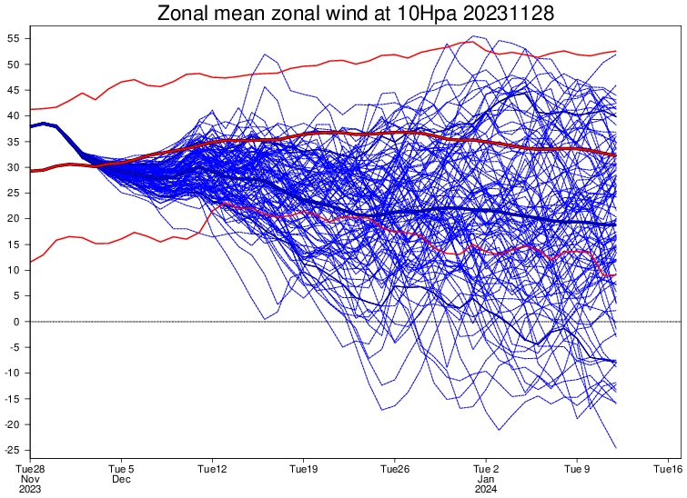
ECMWF ensemble zonal wind forecast at 10hPa at 60N issued November 28, 2023
QBO
The previous discussion on stratospheric polar vortex ties quite nicely into QBO. The QBO refers to the regular variation of winds in the stratosphere high above the equator in the 1950s UK scientists discovered winds above tropics in stratosphere oscillate between westerly and easterly in 28-month cycle. Now you may ask how can something so distant in tropics, influence our weather? The QBO is important as it can affect the polar jet stream.
When QBO is negative (easterly), this indicates greater potential for a weaker jet stream with a greater chance of weaker polar vortex and an increase in cold outbreaks in Europe and parts of North America.
When the QBO is positive (westerly), there is a greater chance of a stronger jet stream with a mild and stormy wet winter, with a strong polar vortex the cold is locked at pole.
What is QBO doing this winter?
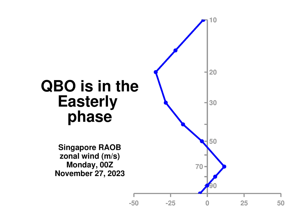
The QBO this winter will be in easterly phase these are quite strong easterlies as a matter of fact typically we look at 30mb level.
During easterly QBO winters as mentioned previously stratospheric westerly circulation tends to be weaker, hence there is a greater risk of a colder winter in Europe and N America. It has been identified that the most receptible environment for a major disruption to the stratospheric polar vortex is when QBO is in an easterly phase with El Nino. We will have both this winter, it is a rare combination, this last occurred in winter 2009/10 which was a very chilly, cold dominated winter. Therefore, one can deduce there is a heightened chance of major SSW this winter, this was part of a catalyst to 2018's Beast from the East but all SSWs are unique. Some even fail to have a response on the tropospheric pattern, I, however, think this is less likely due to mature eQBO. I do think we will see an SSW this winter most likely into January and this could have a profound influence on the late winter period. If it comes together like this, I'd say we could be on for something truly memorable this winter, there is clearly a chance, the vast majority of winters do not present an opportunity like this.
Seasonal Models
ECMWF
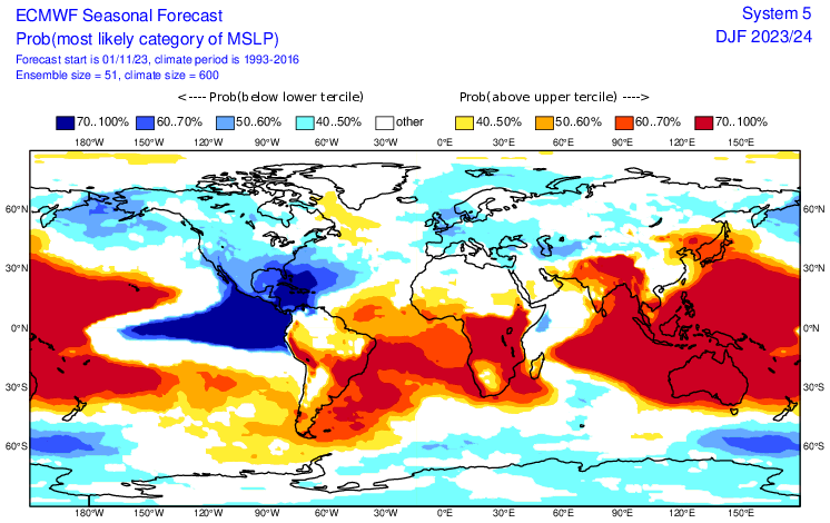
The European (ECMWF) model is often regarded as one of the top-performing seasonal models. There is a weak signal for -NAO, it is not the most conclusive forecast. Note the above-average mean sea level pressure to south of Greenland which suggests a less cyclonic activity exiting eastern seaboard. A stormy and active pattern is expected in southern US, this is typical of El Nino which causes Pacific jet stream to move south and east. Some of the strongest low-pressure anomalies in North Atlantic region are found in UK/NW Europe, this might suggest a wet winter is more likely. It is noticeable though how these more unsettled anomalies are looking quite widespread across Europe even into Med. The model expects Azores High to be less influential this winter, this brings mildest winter weather to Europe, an indication the jet stream will be further south. Overall, for a 3-month mean, this points to a mixed winter with potential for cold spells while probably not severe.
C3S multi-system seasonal forecast Mean MSLP anomaly December + February
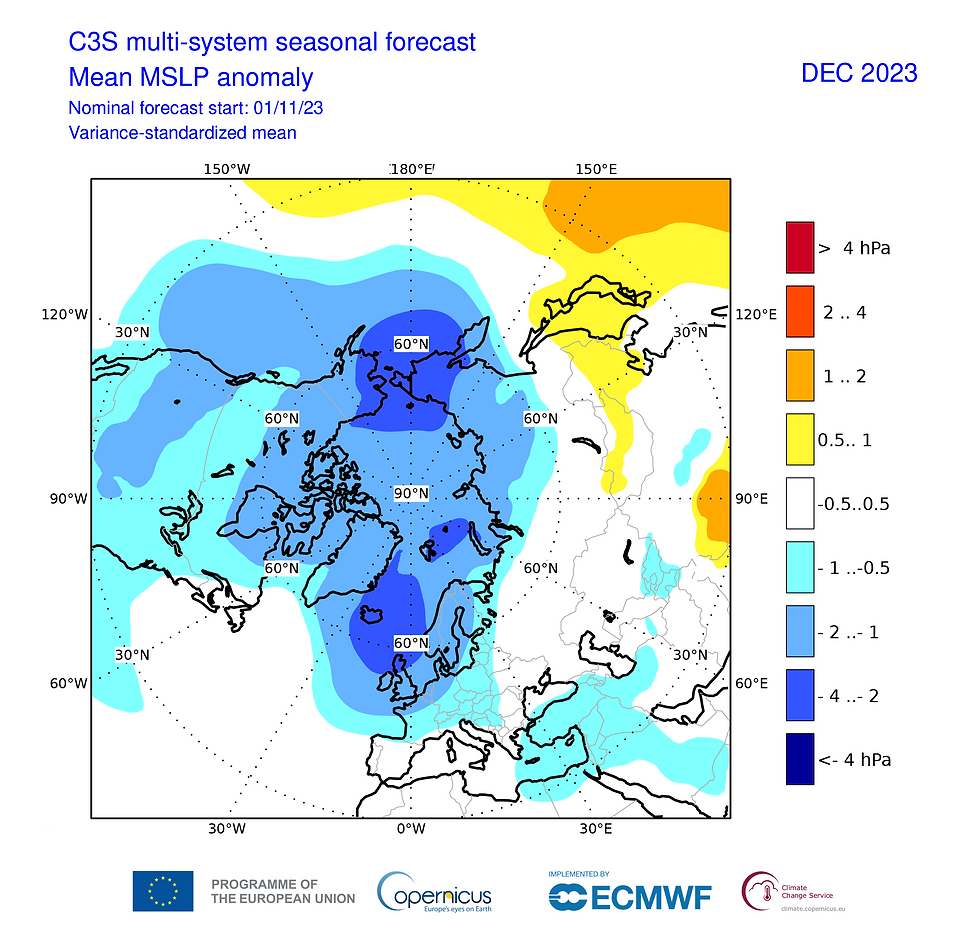

The Copernicus Climate Change Service (C3S) seasonal forecast is based on data from numerous leading prediction systems including ECMWF, Met Office, Meteo-France and more. Therefore, it gives a more holistic look at what best guidance is most strongly favouring. The latest November update reveals a rather strongly contrasting winter with a major difference in atmospheric circulation patterns between early and late winter. Early winter features much cyclonic activity with stronger westerly winds. In late winter we see this flip with cyclonic focus going to southeast Europe with higher atmospheric pressure in North Atlantic and Pole suggesting a reduction in westerly winds it is a classic -NAO/-AO pattern. This is associated with a weak polar vortex. It is clear models are going strongly with ENSO influence with more classic response to El Nino, with the potential for the most harsh winter weather in the second half of winter. In the UK it has been over 30 years since we have seen a very cold February this is something which is significantly overdue. The signal in guidance is interesting and robust perhaps this could be the winter where the 'drought' ends.

Overall thoughts on winter 2023/24
I expect December will be overall close to average, perhaps colder than normal further north expecting a great start to ski season in Scotland. I do not see a shortage of snow this winter. Into the end of week 1, we're likely to see unsettled and milder Atlantic weather with strong winds possible. Overall, I cannot see December being a particularly cold month, I think it will be a very cold month in Scandinavia. The signal is strong for deep cold to be really entrenched to our northeast. It is possible we see another attempt later in the month around Xmas to New Year as tropical forcing comes in.
My thoughts are that January into February is primed to feature the coldest weather of winter, with a major disruptive event to SPV, I think it has the potential to bring significant and persistent cold, with deep -NAO. This block in the North Atlantic could prove very resilient we know in easterly QBO winters, northern blocking where it develops, is able to gain a more secure foothold against westerlies. As discussed earlier, I also believe the Atlantic sea surface temperatures are also rather supportive of a blocking regime in North Atlantic. Seasonal models are also rather bullish on cold wintry risks later in winter, as is more typical from El Nino winter. However, early winter could be disappointing with much rain.
I'm feeling bold the background drivers as discussed are the most supportive they've been in a number of years. This does not guarantee a cold winter, but I believe the risk is higher than in many other recent years.
It is possible this could be the coldest winter since 2009-10 in UK. If the stratospheric warming fails and blocking fails to materialise then it likely will be a wet winter, but probably not overly mild. The dreaded Euro high seems less likely to be a foe this winter.
Thanks for reading, I apologise if much of it went over your head! And as ever keep up with @TheSnowDreamer for the latest shenanigans.
Quite similar to my thoughts. Nice detailed and well explained forecast Daniel.
I believe we will have an hidden gem this winter. It won't all be doom and gloom. Excellent summary with much to look forward to. Thank you.
Very informative and exactly what I wanted to hear this winter! Thanks for the time you've taken to write this all down :).